Soils provide the foundation for our houses and settlements. As the basis of agriculture and forestry, soils are the source of our livelihood. Perhaps more importantly, soils perform vital ecosystem services in filtering and absorbing water, nutrients and pollutants.
As the product of the soil-forming factors - climate, parent material, topography, plant and animal life, humans and time - soils tell us about the past and present environment. An understanding of soils is vital to informed management decisions for any area of land and particularly farm enterprises.

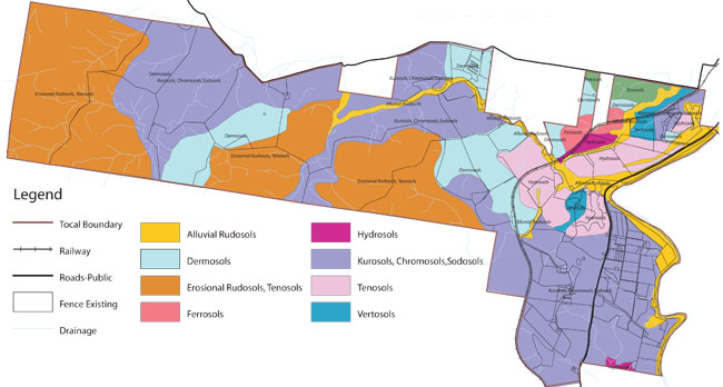
This map and the soil profile information (from the book The Soils of Tocal) provides an indication of the main soils on Tocal and the way that they change across the landscape. The soils are classified according to the current Australian Soil Classification.
As you can see from the map soils form a complex pattern across the property. The pattern can be simplified by looking at the soil landscapes ie the uplands or hills with erosional soil landscapes, the floodplain with alluvial soil landscapes, the midslopes with colluvial soil landscapes and the vestigal soil landscapes that remain as evidence of volcanic activity. These landscapes are then broken down further into the soil types found on Tocal.
Twenty-one profiles across the property have been taken to show the characteristics of each of the soil types. To view more detail of the soil types and view an image of a typical profile click on a profile name in the list below or on an area of the map. The information contains a description of the soil type, the site that the profile is from as well as management issues for the soils.- Soil profile 1 - Windmill paddock
- Soil profile 2 - Bottom Flat at Bona Vista
- Soil profile 3 - the Top Flat
- Soil profile 4 - Homestead paddock at Bona Vista
- Soil profile 5 - Phillips paddock
- Soil profile 6 - Bowkers paddock
- Soil profile 7 - Bowkers Gravelly
- Soil profile 8 - Hedges paddock
- Soil profile 9 - Lucerne paddock
- Soil profile 10 - Calving paddock
- Soil profile 11 - Springer 1
- Soil profile 12 - Springer 2
- Soil profile 13 - View paddock
- Soil profile 14 - Glendarra regeneration area
- Soil profile 15 - Glendara, CMA site
- Soil profile 16 - Glendarra house paddock
- Soil profile 17 - Tank A
- Soil profile 18 - Racecourse paddock
- Soil profile 19 - Racecourse gilgai
- Soil profile 20 - Campus
- Soil profile 21 - Creek paddock
Tocal newsletter
Want to find out about news, events, courses and publications?

