

Fast Facts
Location
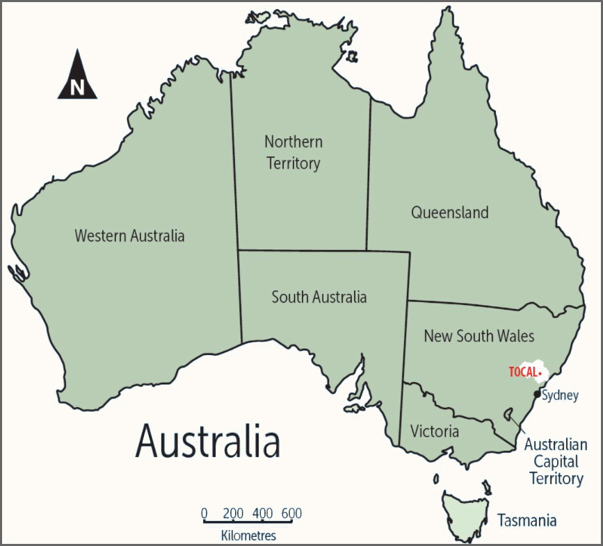
Tocal is located in the lower Paterson Valley of the New South Wales Hunter Valley. The Hunter River is the state’s largest single coastal river system, covering an area of 22,000 square kilometres. The Hunter River system passes through the Great Dividing Range in one of the few east-west breaks in the range. This break marks the geological border in the Great Dividing Range between the Carboniferous mountains to the north and the Sydney sandstone basin of the Permian era to the south.
The Paterson River is one of several tributaries to the Hunter River. Each of these rivers flows from the Barrington Tops (on the southern end of the Carboniferous mountains) into the Hunter River. The valley floor contains relatively recent (around 6,000 years old) alluvium from the Quaternary era.
Tocal is mostly contained in the Webbers Creek sub catchment, Webbers Creek being a tributary of the Paterson River. Tocal almost spans the Webbers Creek catchment and interestingly contains the northern tip of the Sydney sandstone basin in View and Bush paddocks, the Carboniferous mountains on the northern side of the Webbers Creek valley and the Quaternary alluvium of the valley floor (the Top Flat soil profile is an example of the older Quaternary alluvium, while Windmill paddock is an example of the newer lighter alluvium). This mixed geology creates a range of soils on Tocal.
The rim of the Webbers Creek valley rises about 300m above sea level (the peaks of Tocal are around 200m). This rise is the first encountered by maritime air masses moving west from the coast, often creating violent thunderstorms within the Webbers Creek catchment. The Webbers Creek catchment has a noticeably higher rainfall than the areas to the north, south and west. This, combined with the long narrow Paterson catchment and the tidal nature of the Paterson River below Tocal, means that Tocal experiences regular flooding in areas below 10 metres.
Soils
Soils form a complex pattern across the property. This can be simplified by cosidering the soil landscapes, that is the uplands or hills with erosional soil landscapes, the floodplain with alluvial (made up of materials left by rivers) soil landscapes, the midslopes with colluvial (soil accumulated at the base of a hill usually moved by gravity) soil landscapes and the vestigial soil landscapes that remain as evidence of volcanic activity. Each of the soils represents different production and management opportunities.
More information on soils
https://www.tocal.nsw.edu.au/farm-and-facilities/tocal-farms/tocal-virtual-farm-navigation/natural-resource-management#Soils
Water
Reliable and high-quality stock water is required for each paddock on Tocal. The property is fortunate in having areas of wetland, lagoons, creeks and the Paterson River as natural water resources. These water bodies, however, can be easily degraded by poor management, and the results of past misuse are evident.
Pastures and landscapes
As a general rule introduced pastures are concentrated towards the front of the property - the area closer to the Paterson River including river flats and gently undulating land, and native pastures at the back of the property - further away from the Paterson River and including hillier landscapes that contribute to the catchment. The current management objective is to maintain a balance between the two so that we can take advantage of both the adaptive nature of native species to environmental conditions and the higher productivity potential of introduced species.
Weather and climate
Rainfall
Mean = 972 mm, Median = 749 mm.
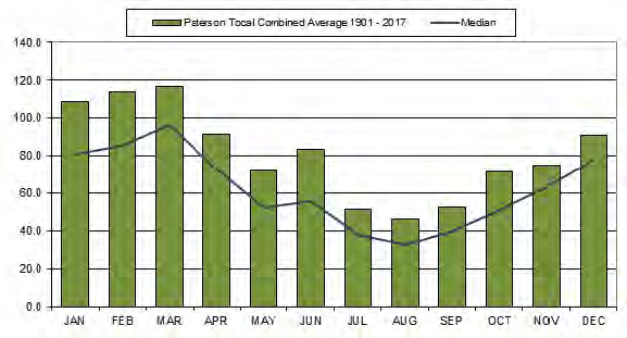
Image: Graph of average and median monthly rainfall at Paterson/ Tocal (1901-2017)
This graph shows both average monthly rainfall and the median at Paterson/Tocal. The average is calculated by adding rainfall totals for each month over the period from 1965 to 2006 and dividing by the number of years. This figure can be misleading, because a couple of very low or very high rainfall years can alter the average significantly. A more useful figure to use for farm planning is the median. Median rainfall is calculated by ranking totals from highest to lowest, the middle figure being the median. The median will often be lower than the average, and is a more realistic figure to use, although it is not often quoted in rainfall statistics.
Temperature
Paterson’s proximity to the coast affects its temperatures by reducing extremes. The area does not receive the intensity of hot days in the summer and cold nights in the winter compared to the Upper Hunter Valley. It is, however, far enough inland to receive some very hot days (>35°C) in most summers and some frosts in most winters.
The following graph shows the average monthly temperatures at Tocal. They indicate a fairly mild climate with few extremes on average.
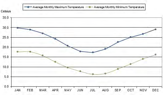
Image: Graph showing average monthly temperature at Tocal from 1971-2017
More details on Tocal's weather and climate are available here.
Seasonal conditions (updated August 2020)
The beginning of 2019 was a continuation of the drier than average conditions experienced through 2017 and 2018. The rainfall distribution across 2019 shows occasional good falls with long dry periods between. January and February were 70% below average rainfall, however, improving in March. This pattern repeated itself throughout the rest of the year.
High temperatures, very low runoff and windy, low humidity conditions in Spring and early Summer led to real concerns regarding water right across the farm. From 1st October to the end of December, a total of 45.4 mm of rain was recorded with one fall of 24.8mm on the 4th November and just 2.0 mm in December. The low rainfall combined with four days over 40 degrees left Tocal in a condition not seen before.
Tocal is considered a very safe farm for water, relying on a number of creeks, streams and over 25 dams. The dairy has very reliable access to the Paterson River and much of the College precinct and surrounds has town water but for the rest of the farm the situation became more critical as the year progressed. Numeralla egg farm relies on one large dam for all water and the dam dropped to below 40% capacity and a daily check was required.
Towards the end of January the rains came and rainfall so far this year is 789.4 mm, with rain distributed well every month. This has completely changed the water and feed situation on Tocal. All dams are full, creeks and streams are flowing and Lostock Dam, at the head of the Paterson River, is now at 100% of capacity. With a mild winter and good soil moisture this is a good start to spring. The long-term prediction from the Bureau of Meteorology is for a warmer and wetter than average spring and summer. It will be time to take full advantage of the return to good seasons.
People
People are an invaluable resource on any farm and probably even more so on Tocal. We have an important role in agricultural education, in our local community, as NSW government facility and as a producer of high-quality beef, eggs, milk and horse breeder.
People, products, services, and ideas flow into and out of Tocal and are influenced by the site and the industry in which we operate.
Nine staff members work full time on the farms. They are supported by up to ten casual staff and teaching staff. They are responsible for students who are rostered on for practical work during term.
These are made up of:
- Dairy: 3 full-time, 2 casual staff members
- Beef: 3 full-time, 1 casual staff member
- Horses: Two teaching staff allocate time to horse management
- Sheep: One teaching staff member allocates time to sheep management
- Numeralla/eggs: Two (full-time Manager and Second-in-Charge) one maintenance + 5-7 casual staff members
The central role of Tocal farm enterprises is to provide the foundation for full time student training, education delivery short courses, industry training and farm visits from schools and the general community and to support DPI research initiatives.
Each week of the student year between 25 and 35 students are rostered onto the various farm enterprises. The students from Cert III and IV Agriculture and Cert III Horse husbandry courses complete a range of practical and skills that support the theory training associated with the course providing a balance between theory and practical skills development.
- Each student will spend 267 hours on the various enterprises during the year. This time is spent under full supervision from College staff.
- Other training areas not included in these hours are farm safety induction training, two weeks at beginning of the year intensive skills training, two weeks skills training for Certificate IV students and the Tocal Agskills challenge.
The following tables summarises the roster hours for 19 practical and skills weeks on the farm enterprises for Tocal students in 2018.
| Individual Student Practical Work rostered for each enterprise | Hours/Student |
| Beef/horse/sheep rostered 5 times at 17 hrs per roster | 85 |
| Dairy/Milking 2 weeks | 70 |
| Numeralla | 35 |
| Farm duties | 35 |
| Dairy 1 weekend | 14 |
| Dairy Holiday Work x 4 days | 28 |
| Total rostered hours per student | 267 hrs |
The Tocal site includes offices of the NSW Department of Primary Industries, Local Land Services and Tocal College. Staff and students from these areas amount to around 100 people.
The government also plays a significant role in Tocal’s production and farm decision making.
State government plays a role mainly in compliance matters particularly in relation to:
- administering and regulation of Workplace Health and Safety (WHS),
- irrigation and access to water,
- the Native Vegetation Act & natural resource management in general,
- the National Livestock Identification Scheme (NLIS)
- biosecurity,
- Award conditions (pay and working conditions) for staff,
- animal welfare,
- food registration, and
- industrial relations.
The federal government influences management of Tocal indirectly including the impact on the economy and exchange rate of government decisions and international agreements and by lobbying for the removal of protectionism. Their direct influence is through compliance issues. The Australian Competition and Consumer Commission also has the power to influence dairy industry profitability but has not yet exercised this power.
Industry trends, innovation and the social licence of farms to operate are also factors that are people based and can have significant impacts on the management and productivity of Tocal.

Farm revenue
Revenues from the farms for 2019-20 Financial year were:
| Dairy | $1,551,655 |
| Free Range Eggs | $843,213 |
| Beef | $658,275 |
| Horses | $88,600 |
| Sheep | $34,906 |
The total farm revenue is a creditable $3,176,649. This income pays for all variable costs of production and some improvements. It also contributes significantly to, but does not cover, all site overheads for the Tocal College farms.
Key management goals
Sustainable agricultural land use management goal:
- to manage the land sustainably
Environmental improvement goal:
- to manage the land so that the environment is continually improved.
Production goals include:
- Improved beef production by managing the land more effectively and the use of an objective recording system to verify improvement
- Increased dairy production by increasing the available feed supply by extending the irrigation systems
- Improved capacity for horse production with improved paddock subdivision, pasture production and tree lots planted and protected
- Sheep production maintained and wild dog attacks eliminated
- To establish and maintain the overall economic goals of each primary production enterprise
- Maintain or reduce the overall cost of production, maximising annual economic return
- Farm and Homestead tourism, and the Tocal Field Days be developed as self-sustaining separate commercial enterprises
- Manage the Tocal property to support the delivery of excellence in agricultural education.
Risks
In addition to the normal risks that businesses face, rural properties and farming activities often face additional risks that go beyond the farm gate and boundary fence. Rural land should be managed with care and responsibility to minimise risks to the enterprise, humans, livestock and the environment.
815 Tocal Rd, Paterson, NSW, 2421
Tocal is located in the lower Paterson Valley of the New South Wales Hunter Valley. The Hunter River is the state’s largest single coastal river system, covering an area of 22,000 square kilometres. The Hunter River system passes through the Great Dividing Range in one of the few east-west breaks in the range. This break marks the geological border in the Great Dividing Range between the Carboniferous mountains to the north and the Sydney sandstone basin of the Permian era to the south.
The Paterson River is one of several tributaries to the Hunter River. Each of these rivers flows from the Barrington Tops (on the southern end of the Carboniferous mountains) into the Hunter River. The valley floor contains relatively recent (around 6,000 years old) alluvium from the Quaternary era.
Tocal is mostly contained in the Webbers Creek sub catchment, Webbers Creek being a tributary of the Paterson River. Tocal almost spans the Webbers Creek catchment and interestingly contains the northern tip of the Sydney sandstone basin in View and Bush paddocks, the Carboniferous mountains on the northern side of the Webbers Creek valley and the Quaternary alluvium of the valley floor (the Top Flat soil profile is an example of the older Quaternary alluvium, while Windmill paddock is an example of the newer lighter alluvium). This mixed geology creates a range of soils on Tocal.
The rim of the Webbers Creek valley rises about 300m above sea level (the peaks of Tocal are around 200m). This rise is the first encountered by maritime air masses moving west from the coast, often creating violent thunderstorms within the Webbers Creek catchment. The Webbers Creek catchment has a noticeably higher rainfall than the areas to the north, south and west. This, combined with the long narrow Paterson catchment and the tidal nature of the Paterson River below Tocal, means that Tocal experiences regular flooding in areas below 10 metres.
A separate more detailed examination of weather and climate at Tocal is available at https://www.dpi.nsw.gov.au/education-and-training/tocal-virtual-farm/property-and-farm-data
Rainfall
Tocal receives more summer rainfall than winter. In January to March there is more than twice the rain of July to September. There are only slightly more rain days in the summer/autumn period, however there are more thunderstorms in summer, bringing heavier falls. Most summer rainfall comes from storms caused by moist air extending southwards from northern Australia and east from the Tasman Sea. Winter rainfall is mainly caused by cold fronts from the mid latitudes. The development of low pressure systems in the Tasman Sea in winter can also bring heavy rain and strong winds (see wind).
The lower monthly rainfall figures from July to September are made much worse by the incidence of strong westerly winds causing high evaporation rates. The district rarely receives really good rainfall in spring compared to southern New South Wales. Reliance on the ryegrasses and clovers as the main feed source is therefore difficult and explains the need for summer growing species such as kikuyu.
Graph of average and median monthly rainfall at Paterson/Tocal (1901 - 2017)
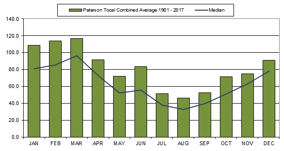
This graph shows both average monthly rainfall and the median at Paterson/ Tocal. The average is calculated by adding rainfall totals for each month over the period from 1965 to 2006 and dividing by the number of years. This figure can be misleading, because a couple of very low or very high rainfall years can alter the average significantly. A more useful figure to use for farm planning is the median. Median rainfall is calculated by ranking totals from highest to lowest, the middle figure being the median. The median will often be lower than the average, and is a more realistic figure to use, although it is not often quoted in rainfall statistics.
When looking at long-term trends, it is more accurate to use figures from as far back as possible.
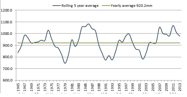
Rolling five-year rainfall averages
The rolling five-year average is calculated by averaging the rainfall figures for the previous five years to get the figure for that year. For example, the 1970 figure is the average of 1966, 1967, 1968, 1969 and 1970. The rolling five-year average is useful because the effects of rainfall (either high or low) do not stop at the end of the calendar year, so a graph of annual rainfall for each year can be misleading. Importantly, the rolling five-year average is a better indicator of trends in rainfall.
The graph clearly shows above and below average periods, with three periods of lower than average rainfall and from 2006, a higher trend.
Graph showing rolling five year average rainfall for Tocal (1965 - 2013)
Evaporation
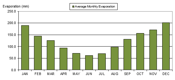
Evaporation is the reverse of rainfall. It is a measurement that can be related to the loss of moisture from the soil and from plants. Evaporation rises as temperatures increase, and as monthly temperatures fall, so do evaporation rates. The graph below clearly shows this relationship. The incidence of westerly winds increases evaporation rates.
Measurements of evaporation have only been recorded at Tocal from 1974 (see graph below), and never at Paterson. It must be remembered that the figures for evaporation are based on evaporation from an open pan (evaporimeter) that is continually replenished. This is why most months of the year get more evaporation than rain. In reality you can never get more evaporation than rain.
Average monthly pan evaporation at Tocal (1947-2017)
Effective Rainfall
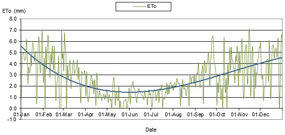
Irrigation schedules are used to ensure efficient water use. Using moisture budgets a farmer can ensure that water is applied to a crop or pasture when it will be of most benefit. Moisture budgets are calculated using rainfall and evapotranspiration.
Evapotranspiration is used because while effective rainfall is a good indication of seasonal conditions, plant water use needs also to be considered. Evapotranspiration combines water used by plants as well as water lost from the soil through evaporation.
Plant water use is influenced by environmental conditions, including wind, temperature, humidity and solar radiation. If conditions are hot, dry and windy, crop water use and evaporation will be high. However, if the day is cool and overcast, water use will decrease. The chart below shows the evapotranspiration measurements and trends at Tocal in 2003.
Chart of the evapotranspiration at Tocal.
Temperatures
Paterson’s proximity to the coast affects its temperatures by reducing extremes. The area does not receive the intensity of hot days in the summer and cold nights in the winter compared to the Upper Hunter Valley. It is, however, far enough inland to receive some very hot days (>35°C) in most summers and some frosts in most winters.
Graph showing average monthly temperature at Tocal from 1971-2017
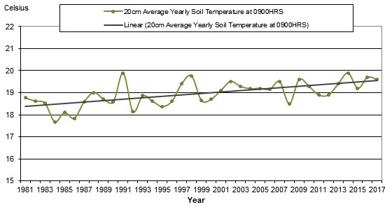
Soil temperature
For root crops like potatoes and for seed germination of crops like maize, the temperature of the soil is more important than that of the air. Potatoes need a soil temperature of at least 8°C, no more than 28°C with an ideal temperature of about 18°C, which is the minimum temperature for germination of sorghums and millets. The latter crop, as well as maize, are grown for fodder at Tocal, and are likely to be planted earlier than in past years.
Soil temperature graphs follow the air temperature measurements, without the daily fluctuations common with air temperatures.
By looking at the trend line on the soil temperatures, it is clear that the temperatures are rising over time, even though there are yearly fluctuations. The combination of air and soil temperatures show the effects of climate change.
Graph showing average yearly soil temperature at Tocal 1981-2017
Frost
Severe frosts are uncommon at Tocal. When they occur, they are associated with stationary high pressure systems and still, dry air in mid-winter.
Graph showing average number of frost events from May to September
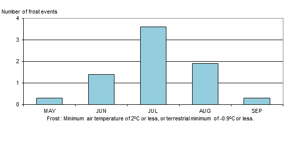
The frost figures show that, as expected, July experiences the most frosts, with August the next most frost-prone month.
Wind
The Paterson district receives quite a lot of windy days, an important factor to be considered when planning agricultural enterprises. This first graph below shows that the strongest winds occur between June and September. Winds coming from the north-west or west in September and October are beginning to warm up, and can quickly ‘burn off’ the spring flush of white clover. This important pasture legume is an important feed source in summer, but can almost disappear in the face of these hot north-westerlies.
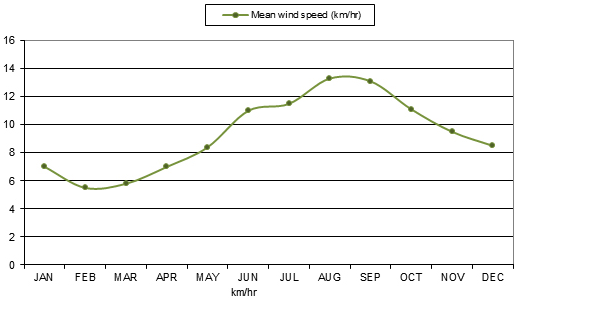
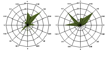
It is also important to look at the direction that wind comes from and the number of windy days in the year. Westerly winds blow at Tocal from May to September and easterly winds prevail during the rest of the year. Winds bringing rain are mostly from the south and east from over the ocean. West winds are usually very dry by the time they reach Tocal as they have lost any moisture they may have had in crossing the Great Dividing Range. In summer, a sea breeze often reaches the area by mid to late afternoon.
The following graphs, described as wind ‘roses’ are representative of the wind occurrences recorded automatically by the Bureau of Meteorology. Note that they do not represent the strength of the wind, but the number of times wind came from that direction. So, for example, in March, the wind came from a south-easterly direction on about thirty occasions. Only two representative samples of months have been noted here because they illustrate the change in wind direction through the year.
Graph showing average monthly wind speed
Tocal experiences irregular summer wind storms that have been responsible for significant damage to buildings and infrastructure from time to time.
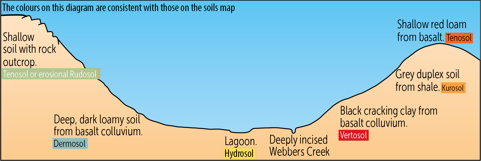
Soils provide the foundation for our houses and settlements. As the basis of agriculture and forestry, soils are the source of our livelihood. Importantly, soils perform vital ecosystem services in filtering and absorbing water, nutrients and pollutants.
As the product of the soil-forming factors - climate, parent material, topography, plant and animal life, humans and time - soils tell us about the past and present environment. An understanding of soils is vital to inform management decisions for any area of land and particularly farm enterprises.
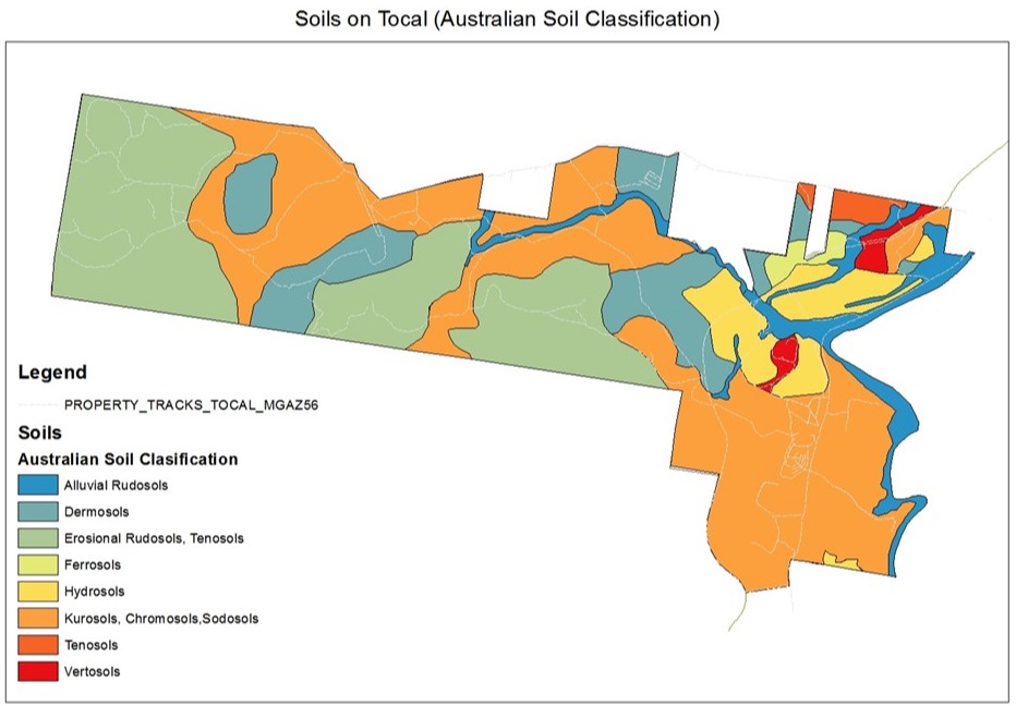
This map and the soil profile information (from the book The Soils of Tocal (www.tocal.com) provide an indication of the main soils on Tocal and the way that they change across the landscape. The soils are classified according to the current Australian Soil Classification.
As you can see from the map on page16, soils form a complex pattern across the property. This can be simplified by looking at the soil landscapes: the uplands or hills with erosional soil landscapes, the floodplain with alluvial (made up of materials left by rivers) soil landscapes, the midslopes with colluvial (soil accumulated at the base of a hill usually moved by gravity) soil landscapes and the vestigial soil landscapes that remain as evidence of volcanic activity. Each of the soils represents different production and management opportunities.
Soil landscapes on Tocal
On Tocal we have:
Erosional soil landscapes; the uplands and rolling low hills, on Permian sediments which cover much of Tocal. The Tocal landscapes featuring erosional soils are:
- Kurosols, Chromosols and a few Sodosols. They have an abrupt change in texture between A and B horizons. See site 8 from Hedges paddock for a Kurosol soil and site 16 from Glendarra House paddock for a Sodosol.
- Tenosols which are gravelly soils found on ridge crests. See site 7 from Bowkers Gravelly.
Alluvial soil landscapes; these soils developed from recent or ancient alluvium on the extensive floodplains built up by the Hunter and Paterson Rivers. The Paterson landscape is on coarse-textured alluvium and Webber’s Landscape is on fine-textured alluvium. The Tocal landscape featuring alluvial soils are:
- Rudosols, see site 1 from Windmill paddock
- Hydrosols, often puggy and waterlogged. See site 3 from the Top Flat and site 18 from Racecourse paddock
- Vertosols or cracking clay soils. See site 19 from the Racecourse paddock gilgai and site 5 from Phillips paddock and
- Chromosols, Kurosols and Sodosols. Site 8 in Hedges paddock is a mix of these categories.
Colluvial soil landscapes; soils in these landscapes have developed from parent material that has moved downslope from uphill and ended up in the present landscape. The material that has moved is called colluvium. Tocal has examples of soils that have developed from basaltic colluvial material, the landscapes featuring basaltic colluvial soils are:
- Chromosols, Kurosols and Sodosols (see site 8)
- Dermosols, these include basaltic Dermosols on sites 10 and 11 from Calving and Springer paddocks.
The Tocal landscape featuring vestigial basaltic soils are:
- Ferrosols, see site 6 Bowkers Red and part of Dunnings Hill and Sheep paddocks
- Dermosols in Numeralla and Dunnings Hill paddocks and see site 9 Lucerne paddock and site 2 from Bottom Flat.
Position in the landscape influences the type of soils found across a property.
Soil profiles
Twenty-one profiles across the property have been taken to show the characteristics of each of the soil types. More information about the profiles is available in ‘The Soils of Tocal’ and on our story map (https://www.arcgis.com/apps/MapSeries/index.html?appid=be34e7c52a6249c8a6e74219dfed3f4e). It is important to understand the soils of a property as different soils require different management and allow for different land uses. Three profile overviews are presented here as an example of the range of soils and their management.
Sustainable agricultural land use management
Goal: to manage the land sustainably
The underlying principle is ‘to use the land according to its capability and protect it according to its needs’. In essence, this means that land has a capacity to support agriculture production, but when used beyond its capacity it becomes subject to degradation.
Key Indicators: (not in order)
- Weed control program developed, implemented and monitored, eliminating isolated weeds first to prevent further spread
- Fencing program developed, working from areas of high priority to areas of low priority
- Pasture improvement program developed for all paddocks on a rotational basis
- Access tracks, fire trails and fence lines cleared/constructed and maintained
- Grazing pressure kept in balance with pasture viability, and woody regrowth suppressed in grazing areas
- Soil fertility monitored, and sustained
- Bare soil areas in grazing areas sown
- Livestock production maintained or improved
- All infrastructure maintained and operational
- Pests and disease control strategy implemented and monitored.

The different landscapes on Tocal are carefully managed for sustainable production.
Environmental improvement
Goal: to manage the land so that the environment is continually improved
Key Indicators: (not in order)
- Land use in keeping with the capability of the land
- Soil pH and soil fertility that is maintained or improving
- Effective weed control
- Tree health maintained, woody regrowth suppressed and less dieback
- Native and improved pasture maintained with ground cover kept above 90%
- Biodiversity improved. The underlying approaches being to:
- slow the rate of biodiversity loss and start to reverse the decline (short term focus and develop indicators for benchmarking to be carried out)
- increase the extent and diversity of areas of biodiversity and ensure they can persist in the long term (long term focus)
- establish green corridors by extending the fencing of Webbers Creek and establishment of native species, connecting the creek with wetlands and Quarry Creek
- establish the southern end of Ridge paddock as a Voluntary Conservation Area for future offsetting of development impacts and for government biodiversity investments and removing or reducing grazing pressure (controlled grazing) to allow for natural regeneration of native plants
- control exotic plant species that compete with native species
- leave fallen timber on the ground to provide shelter for wildlife (this should not prevent vermin control which is a priority and not to be compromised)
- control feral animals (rabbits, pigs, foxes, cats and wild dogs) that pose a threat to native plants, farm animals and wildlife populations
- plant or regenerate locally indigenous trees, shrubs and grasses
- Improve water quality sufficient to maintain ecosystems
- maintain buffer zones around waterways and drainage lines
- maintain species diversity (flora and fauna)
- Improve soil health
- stream health improved for a fish friendly farm
Energy consumption reduced
Climate and climate change trends monitored and adjustment made as required (eg adequate shade for stock and stock water reserves).
Production goals
- Improved beef production by managing the land more effectively and the use of an objective recording system to verify improvement
- Increased dairy production by increasing the available feed supply by extending the irrigation
- Improved capacity for horse production with improved paddock subdivision, pasture production and tree lots planted and protected
- Sheep production maintained and wild dog attacks eliminated
- Establish and maintain the economic goals of each enterprise
- Maintain or reduce the overall cost of production, maximising annual economic return
- Farm and Homestead tourism, and the Tocal Field Days be developed as self-sustaining separate commercial enterprises
- Manage the Tocal property to support the delivery of excellence in agricultural education.
Refer also to the Tocal Code of Land use Practice (Archer and Brouwer 2004).
Risk management
Risks are encountered continually, but not all risks and incidents have the potential to result in harm or impact on an actual or planned business activity. A risk is measured in terms of the likelihood of the risk happening and the consequences if it does happen. Risk management is the process used to identify and assess the risks, and the system implemented to avoid, reduce or control the risks.
In addition to the normal risks that businesses face, rural properties and farming activities often face additional risks which the average person may not be aware of. Rural land should be managed with care and responsibility that goes beyond the farm gate and boundary fence. What occurs on a holding can affect neighbours and other landholders in the catchment and there is legislation that addresses many risk and farm safety issues. Tocal has areas of risk that need to be managed for human, livestock and environmental safety and to ensure that the enterprise, humans, livestock and the environment are not harmed.
Some of these risks or hazards are listed as follows:
Human activity:
- Livestock handling (eg operator and stock handling injuries especially in yards)
- Outdoor education activities and medical emergencies
- Tourism, Field day and visitor medical emergencies and accidents
- Steep terrain (eg vehicle and horse riding accidents caused by steep slopes)
- Riverbanks (eg slipping into water and drowning)
- Concealed objects and ruts (eg riding quad bikes in long grass)
- Flooded streams (eg driving across or horse riding)
- Accidental damage to services (eg ripping up the Telstra optic fibre cable, collision with or damage to power lines, rupture of underground pipelines)
- Zoonoses (eg Q Fever)
- Poisoning and allergic reactions (eg snakebite, use of agricultural chemicals, plant toxins)
- Cultural heritage preservation (see Cultural Heritage section)
Livestock
- Insecure boundary fences allowing stock to escape or neighbouring stock to enter, breaching quarantine which endangers disease free status, disrupts the breeding program and wastes time returning stock
- Metabolic disorders caused by sudden changes in diet, or plant toxins, (eg ketosis in Ridge paddock)
- Plant poisoning (eg Green cestrum, Lantana)
- Physiological and nutritional disorders (eg bloat, starvation)
- Disease, parasites and biosecurity
- Uncontrolled stock access to roads and railway and the chance of collision or causing an accident
- Danger of stock slipping or falling into water due to very steep stream and river banks
- Soil chemical residues ( refer to Soil Chemical Residue section)
- Livestock attack by feral animals (eg dog attack on sheep, dingo attack on calves)
- Stock trapped with rising flood waters
- Accidental injuries in the field or yards (eg stock injured on a fence)
Environment
- Chemical use or misuse (eg chemical spill, contamination of a waterway, spray drift)
- Fertiliser use or misuse (heavy rain storm event after application, application too close to a waterway)
- Erosion (eg road or track, overgrazing, cultivation of drainage line, storm event on cultivation, stock tracks on slopes or riparian areas) (see Problem areas- Erosion and Steep Slopes sections)
- Bushfire
- Flood
- Drought
- Environmental weed invasion (see Weeds section)
- Maintenance of biodiversity
- Odour offence to neighbours
- Noise offence to neighbours
In NSW there are legislative requirements to control risk, in regard to human occupational health and safety under workplace health and safety legislation. Risk management is an essential part of Tocal’s farm management where the likelihood and consequences of a risk occurring must be assessed. Safe Work Method Statements (SWMS) are used for this purpose, and from these a system is implemented to eliminate, avoid, reduce or control the risk.
Many other farm risks are controlled under various legislation and owners and managers need to be aware of their legislative responsibilities. Legislation which may impact on a farm, surround:
- Animal welfare
- Biosecurity
- Chemical use
- Cultural heritage
- Environmental protection
- Fire
- Food production
- Local government
- Mining
- Threatened species
- Use of water, soil and vegetation
- Weeds
- Workplace health and safety legislation.
A useful reference is ‘Put yourself in the picture, caring for your small rural property Brouwer, 2006’ – available online from tocal.nsw.edu.au. The Environmental Defenders Office, Sydney, is a useful contact.
Some years ago Tocal established a Code of Landuse Practice in an attempt to record a philosophy or approach to land use that leads to sustainability - defined here as ‘getting the best production from the land without limiting chances for future generations to do the same’.
This section considers the management of natural resources, pollution control, conserving our cultural heritage and landscape values with an attitude of stewardship towards the resources rather than ownership.
Ecological management of the property and production is becoming increasingly data driven with the staged introduction of precision agronomy principles and practice. Management decisions consider a range of soil mapping and tractor data that are ground truthed with soil tests and visual observations and combined with satellite and drone captured NDVI imagery. This data is used to operate the autosteer technology on a number of our tractors and drives the variable rate spreader to ensure the right amount of soil or crop treatment is applied only where it is needed.
Natural resource management
The policy identified for the environment is:
That monitoring of ecological processes be undertaken to evaluate the success of environmental programs
While we consider each of the natural resources in turn, remember that they co-exist and interact in a landscape.
Climate
Climate and weather affects all operational decisions at Tocal. Some of the influences are:
- strategic and tactical seasonal decisions take into account climate variability
- stock numbers, pasture management and irrigation frequency are adjusted for seasonal conditions
- seasonal forecasts are used in planning, for example, de-stocking and feeding policies in times of drought
- dry seasons will cause major revegetation plantings to be held over
- flood warnings are used to determine pump removals and stock movements
- shade and shelter is planned for livestock in all paddocks
- ventilation of poultry sheds is designed to take into account weather extremes
- timing and type of cultivation for sowing must take into account the chances of erosive rainfall occurring, especially in summer storms
- a general trend of climatic warming has been recorded at Tocal, which appears to be part of a global phenomenon.
The policy for climate is:
That climate variability and extremes be taken into account in all operational planning in the college land.


Climate variability is having an increasing impact on weather experienced at Tocal – both these photos were taken in 2018.
Soil
Soil is the basis for agricultural production and vegetation, therefore protection and improvement of the soil is our aim. Understanding the nature of the soil allows us to use the land in the best possible way.

Soils along the Paterson River are capable of producing regular fodder crops
The first policy for soils is:
Soil will be kept healthy and fertile by appropriate management. The following practices aim to maintain or improve soil health:
- Maintain ground cover at a minimum of 90%
- Fertilise to increase production from and persistence of introduced, productive species and maintain high organic matter levels
- Use land according to its capability and use information such as soil tests to assess each paddock
- Ensure the health of soil microbes and beneficial organisms by reducing compaction and by maintaining soil fertility, an efficient water cycle, suitable pH levels and recycling of nutrients to encourage dung beetles and earthworms
- Ensure the soil structure remains intact by preventing overgrazing, soil compaction and inappropriate cultivation and by preventing erosion that exposes sodic subsoils
- Match the water entering the soil profile with healthy plant growth so waterlogging and soil salinity problems do not emerge
The second policy for soils is:
Soil problem areas will be identified, mapped and remedied by conservation works or management. Existing soil problems or potential problems will be addressed by the following:
- Grade banks protect farm roads from erosion. To remain effective they must be kept in good repair and protected from degradation by stock trampling or vehicle passage
- Where gully erosion has occurred in the past, farm dams have been constructed to stabilise the area. To ensure they remain effective the areas will be fenced off from stock access as funding allows
- Soil structure declines through compaction by grazing animals, inappropriate cultivation or overcropping and by overgrazing. Use of minimal tillage cropping in appropriate areas, cropping rotation and careful management of grazing will minimise soil structure decline
- The coastal soils of Tocal are naturally acidic and acidity increases with the use of introduced pasture species, especially legumes, and the use of fertilisers, especially nitrogen. Soil tests are used to monitor soil acidity levels and fertilisers are carefully chosen to reduce the risk. Lime is applied to paddocks that show levels of lower than pH 5.5 (Calcium chloride test)
- Few soils on Tocal show signs of salinity. Healthy perennial pastures with adequate treed areas will help ensure this does not become a problem
- Some areas around the Tocal Homestead wetland have been identified as Potential Acid Sulphate Soil areas. Currently there is no evidence of acid sulphate, however these areas will be permanently reserved as wetland and managed so they are never drained or excavated to expose the acid sulphate soil problem
- Soil tests are used to monitor soil fertility. Fertilisers are only applied according to soil test results, where economic responses can be expected and off-site impacts can be avoided. Soils that are infertile, shallow or not sown to introduced species are not fertilised and grazing of native species is limited and strategic - designed to maintain the natural vegetation cover without losing of degrading species.
More detail on the soils of Tocal is available in the publication ‘The Soils of Tocal’ available online.
Water

Stock water is available in natural and artificial dams and lagoons
Reliable and high quality stock water is required for each paddock on Tocal. The property is fortunate in having areas of wetland, lagoons, creeks and the Paterson River as natural water resources. These water bodies, however, can be easily degraded by poor management, and the results of past misuse are evident.
In order to protect the natural water resources:
- Water sources will be protected from degradation and managed to maintain high quality water and a stable riparian zone
- A policy of providing alternative water sources in the form of dams and troughs rather than relying on the natural water courses will be implemented.
- Irrigation water is a vital component of the Tocal dairy. Water is pumped from the Paterson River which is tidal at Tocal. Water quality for irrigation is usually satisfactory, although in times of drought, salinity readings may rise to unacceptable levels.
The policy for irrigation is:
- Irrigation will be applied efficiently: matched to plant and soil type, to ensure that crop and pasture growth is not restricted by lack of supply, and that excessive watering does not add to groundwater supplies.
- Protective works have been carried out on several fragile wetlands, including the Bona Vista lagoon (beginning in 1981), wetlands in Racecourse paddock, and the establishment of an artificial wetland/dam in Railway paddock.
The policies on wetlands are:
- More wetlands are to be protected and rehabilitated through fencing and plantings
- Dam building will incorporate wetland areas.
- The health of the waterways on Tocal have a direct effect on the water quality of the Paterson River.
- Major waterways will be progressively fenced off and managed for biodiversity.
- The fenced off areas will be managed to reduce weed invasion and planting of native species will be carried out if natural regeneration fails. Alternative arrangements for stock water and shade will be made.
A final policy for protecting water resources is:
- Water problems will be identified, mapped and managed to improve the condition of the water and the surrounding landscape.
- Planning of farm enterprises and site works, as well as drought plans and water conservation plans must ensure there is adequate water available for stock
Water quality issues must also be taken into account including muddy water, saline water, and water contaminated with animal manure or chemicals entering water sources. Protective works on the Tocal wetlands will ensure that they are as efficient as possible at filtering some contaminants; restricting stock access to dams will reduce pollution of dams, as will careful application of fertilisers so the nutrients do not enter the dam; and finally buffer strips around all waterways will improve water quality by preventing erosion, removing stock and filtering the inflow of water.
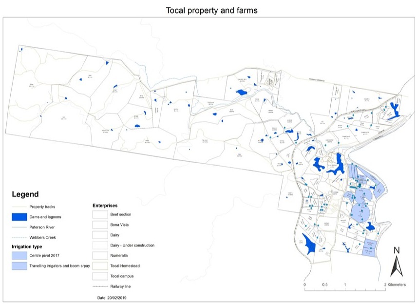
Map of Tocal showing natural water sources as well as irrigation and troughs
Vegetation
Protecting and increasing biodiversity is in every farmer’s best interests. Maintaining a wide range of native plants and animals in an agricultural environment maintains the health of an ecosystem meaning it is more resistant to invasion by pests and diseases. A healthier ecosystem is stronger and more productive. Vegetation management on Tocal is in accordance with our Property Vegetation Plan agreed to under the Native Vegetation Act 2003.
Carefully thought-out tree planting can be important to improving biodiversity and pasture and livestock production.
The policy for increasing biodiversity is therefore:
- That tree planting be continued to achieve a more balanced landscape.

- Pastures in Bush paddock
Pasture and grazing management on Tocal identifies areas to be pasture improved, areas for production within the land’s natural capacity, while other areas are designated as habitat areas. This approach provides for land with high potential to be improved and grazed as well as for habitat areas within these paddocks. Those areas will also provide shelter for livestock.
The policies for pasture management and grazing are:
- That the best land be improved and maintained at a high level of production
- The use of artificial fertilisers will be closely monitored and targeted
- A grazing strategy will be developed for the beef pastures
- Native pasture areas will be encouraged through strategic burning and grazing, and minimal use of fertiliser in designated areas
- Shade and shelter will be provided in all grazing paddocks.
Substantial areas of existing bushland are found in Ridge, Bush and Top Bush paddocks. These areas are managed to maintain biodiversity and tree cover. Maintenance of tree cover will also retain trees with hollows which are important for many breeding birds and critical habitat for many animals; it will avoid erosion in steep areas; and identify areas where selective thinning can supply some on farm uses of hardwood species.
The policies for managing tree cover are:
- That there be minimal felling of old growth trees
- That only selective clearing of fencelines in bushland areas be carried out
- That current timber resources be classified and managed for both timber production and habitat purposes.
Management of vegetation on Tocal provides for habitat for animals, birds, insects and fungi. Rotting, hollow timber and dead standing trees and rocks provide important habitat and will only be removed for safety or efficient paddock management. Wildlife also need to move around the property safely. To this end a network of wildlife corridors are being planted to encourage wildlife to range from riparian zones to the top of ridges. Added benefits are seen in reintroducing understorey species, removal of livestock from creeks and protecting pastures with windbreaks.
The policies for maintaining habitat are:
- That dead trees, fallen timber and rocks be left in place
- That wildlife corridors be constructed of left intact in the grazing landscape.
Fire is an important and useful tool in managing biodiversity and controlling hazards. More research into the use of fire is needed for a policy to be set. Any burning policy will involve conflicting demands, and will need some compromises to be agreed on.
A plan for strategic burning of bushland areas will be developed.
Weeds can cause problems ranging from nuisance value to serious threats to production and biodiversity. Tocal is in a warm temperate area with a wide range of tropical and subtropical weeds. Appropriate grazing management is the key to controlling many weeds in pastures. A weed control strategy will be developed to target weeds in their location as well as annual control measures.
- African Olive (Olea Africana syn. Olea europaea subsp Africana)
- Balloon Vine (Cardiospermum grandiflorum)
- Water hyacinth (Eichornia crassipes)
- Lantana (Lantana camara)
- Green cestrum (Cestrum parqui)
- Fireweed (Senecio madagascariensis)
- Giant Parramatta Grass (Sporolobus indicus var. major)
- Thistes (various).
The policy for weeds is that a weed risk assessment will be completed.
Organisms
Other organisms apart from vegetation contribute to the biodiversity of a landscape. They range in scale from wildlife such as kangaroos and dingos to micro-organisms that are vital for soil and plant health. The also vary greatly in their effects: some organisms are toxic to plants (some fungi and bacteria) or feral to the land (foxes and rabbits) while others provide great benefits (earthworms and mycorrhizae or ‘friendly fungi’).

Eastern Grey kangaroos are a common site below Tocal Homestead
Encouraging beneficial organisms
Maintaining a range of native animals in the local ecosystem adds to biodiversity. The more diverse the ecosystem, the less susceptible to pests and diseases it is. The populations of birds and small animals that directly control insect numbers contribute directly to grazing production. The place of kangaroos and wallabies is more debatable. Previous studies suggest local kangaroo numbers are fairly stable, and do not pose a threat to grazing productivity. Indeed, their presence adds to the ambience and tourism potential of Tocal.
The policy for encouraging beneficial organisms is that native wildlife continue to be protected.
Dealing with problem organisms
At various times feral animals pose a threat to the land and to livestock. The threats include wild dogs (including dingos), pigs, rabbits and foxes. Where necessary, control measures are implemented. Control campaigns are conducted according to strict guidelines, following advice and recommendations from Local Land Services, and safety (warning) signs are displayed at these times.
Other problem organisms may include diseases in plants or animals, insect attacks on pastures or crops or parasites in livestock. None of these poses a major threat, although the risk of exotic diseases is always present for Australian agriculture. The protocols and recommendation of the Department of Primary industries will be followed for the control of any of these organisms, including cooperating and communicating with adjoining landholders.
Pollution control
Controlling pollution and contamination on farms can help profit as well as the environment. Over-use of fertiliser wastes money and adds unwanted nutrients to creeks and rivers. Agricultural chemical sprayed near watercourses are a waste and a hazard.
The issues in pollution control that apply to land use are:
- fertiliser use
- agricultural chemical use
- chemical residues
- waste management.
The policies for pollution control are:
- Agricultural chemicals will be used as little as possible, and only if fully justified
- Care must be taken to prevent unwanted side effects of chemical use including loss of non-target plants and soil organisms. Particular care needs to be taken near open water and drainage lines to reduce risk to aquatic organisms
- Chemical residue areas will be identified.
- Areas containing chemical residues will be described and recorded in property maps, information publications and on a Global Positioning System. This will enable others to learn from how the College has dealt with these problems and will put them in the public domain.
The areas in question are:
- organochloride residues in the main yards
- organochloride residues from foundations of the former cottage at Bona Vista, now the rainforest plot
- possible chemical residue from the past use of dieldrin super to control black beetle on dairy pastures in 1971 in Lagoon, Section IIA, Section IIC, Section IIIA3 and Windmill paddocks
- the former chemical disposal pit in Quarry paddock
- the previous chemical storage site between Apple and Horse paddocks - this was bunded and well maintained but should be monitored into the future
- the old timber treatment sites using copper chromium arsenate (CCA) in Run and Quarry paddocks.
Any waste generated by College or agricultural activities will be disposed of in an approved manner, taking into account the environmental consequences of any actions.
Dairy waste management
The College dairy uses a two pond aerobic and anaerobic treatment system. After a period of storage, wastes are pumped out onto pastures via centre pivot irrigation system over an area of 35ha. The system needs ongoing monitoring and management to ensure that effluent does not seep into watercourses. Milk from the dairy that may be unsuitable for delivery to the factory will be drained into the dairy effluent ponds before spraying on pastures. This is only suitable for small quantities. It is important the milk not enter watercourses.
College effluent disposal
Effluent is sprayed on the Horse paddocks after it is treated in the College treatment plant. This is approved by the Environmental Protection Authority and subject to licence conditions. Performance of the treatment plant is monitored according to the guidelines set down by the EPA and Public Works. Treated water is checked regularly for phosphate, nitrate and ammonia.
Disposal of dead animals
In the past, animals have been disposed of by burying, dropping into open pits and burning. There are difficulties with all of these methods, and alternatives need to be considered. A composter is used at the Numeralla chicken farm for dead birds. Large animals are disposed of in a pit, which is covered with fill. Where possible, a local pet food supplier is contacted before the death of a large beast.
Disposal of rubbish
No rubbish, refuse or other material is to be dumped on the property except for a specific purpose. This means that no parts of the farm should be used as a dump. All refuse is to be removed and taken to the appropriate council-approved facility. Sometimes clean fill is needed for road building, yard base or similar works. This is the only type of dumping permitted. At times piles of wind-thrown timber will be burnt, and CCA-treated timber, metal fittings or non-flammable materials will not be added to these piles. College educational activities and the College dining hall produce a large amount of rubbish. A satisfactory recycling system will be investigated to deal with this rubbish.
Quarry Creek Wetlands
The wetlands area in Racecourse paddock collects the discharge from Quarry Creek. Pollutants from the catchment of this creek, which is not on college land, will be stripped from the water by wetland vegetation before it re-enters Webbers Creek and thence to the Paterson River. This measure will guard against the problems of pollution caused by any closer settlement in the headwaters of this creek system.
Conserving cultural heritage
The farms at Tocal show evidence of human occupation over the last 40,000 years. The strongest imprint was made in the first 200 years, but there still signs of earlier land use. The College values these and will seek to preserve this heritage.
There are a number of significant buildings on the property, including two homestead complexes at Tocal and Bona Vista. The Burra Charter sets out principles and practices in the preservation of these areas. The College must abide by the Charter in the Homestead areas. Its philosophy should be applied to the whole property where ever possible in order to preserve the heritage setting that gives the Homestead its sense of ‘place’.
- Significant sites of Aboriginal and European history will be recorded and conserved.
- Significant sites of agricultural history will be conserved and interpreted.
As a general rule introduced pastures are concentrated towards the front of the property and native pastures at the back of the property. The current management objective is to maintain a balance between the two so that we can take advantage of both the adaptive nature of native species to environmental conditions and the higher productivity potential of introduced species.

Pastures looking across the beef section from View paddock
Historical distribution
The current distribution of native pasture in the lower Hunter is a reflection of management and climate, particularly in the last 200 years. Before European settlement there was probably similar pasture types but management was very different. There was probably a greater variety of native pastures and a different distribution of pasture types under those conditions.
Pre-European settlement, fire also played a greater part in the local ecosystem. There is still a lot of burning in this district particularly on hill slopes in spring, but Aboriginal land management included more warm season burning and maybe autumn burning as well. As a result of that there is a good chance that some of the yearlong green perennial species like Weeping Grass and Wallaby Grass were more common than they are now. The grazing by native herbivores unrestricted by fences and with few permanent water sources would have favoured areas of recovery and seed production.
Current growth patterns and distribution
Currently the more resilient species tend to be the summer growing native pastures, particularly the taller warm season species like Kangaroo Grass and Barb Wire Grass. They dominate in areas of poor soil, for example the slopes and around the timbered areas. They are not particularly resilient to grazing so are often grazed beyond their capacity, especially in dry conditions. These species have therefore been replaced by shorter warm season species like Couch and Carpet Grass. Where fertility has been increased artificially, Kikuyu and Paspalum will also be more prevalent.
Species such as Weeping Grass and Wallaby Grass are more palatable than some of the other native species in this region so they are grazed more heavily and are therefore less common. Weeping Grass tends to be mainly on the better soils and protected areas. Wallaby Grass is not very common at all. It is restricted to areas that have been excluded from grazing for quite some time, where small remnant populations have managed to hold on.
On Tocal
Bowkers Paddock at the back of Bona Vista is a 40 hectare paddock that has had very little inputs since the 70s. This area of the property was set aside from conventional management and allowed to keep ticking over naturally. There are still some representative areas of native pasture in that paddock but once again the introduced summer growing species like Paspalum, Couch and Carpet Grass are also well represented and really take the dominant role, particularly in a wet summer season. Sheep grazing has been the dominant use of Bona Vista but in recent years more cattle have been introduced. There is probably some change in the distribution of pasture species as a result.
There are also strong native pasture communities in Bush and Shell paddocks. There are patches of Wild Sorghum, which is a large tussocky grass that grows particularly well on hill slopes on better soil types. It is good for slowing down water movement so its large tussocky nature stabilises hill slopes. Wild Sorghum also occurs in patches closer to the College. Hill paddock behind the Homestead contains some Wild Sorghum.
Other native grasses that are found around the farm are:
- Wire Grasses or the three awned wire grass (Austrostipa species). It is a summer growing species, is relatively unpalatable and it can increase under continuous stocking. There are patches in Bush paddock as well as isolated plants in many other paddocks including Hill paddock.
- Weeping grass (Microlaena stipoides) is common in many paddocks across Tocal and is especially abundant in shaded areas.
- On Hill paddock there is also some Red Grasses which are Bothriochloa species. It is a slower growing short warm season native perennial grass that can cope with difficult conditions. It isn’t particularly palatable although some areas do get reasonable production from it.
- Along the railway line below Hill paddock there are patches of Queensland Blue Grass (Dicanthium sericeum), a very palatable native grass which is quite productive. There are also patches of it in other paddocks. The Queensland Blue Grasses prefer good soils and rainfall and are far more common in the Upper Hunter.
- Behind the tennis courts is some Plains Grass which is an Austrostipa species. It is a reasonably palatable grass, and there are a couple of isolated pockets of it towards the riverbank behind the Homestead. Once again it is a grass that was probably more common across the flats years ago which has been taken out by continuous grazing and pasture improvement by people who were looking for more productive winter pasture. This is unfortunate because it is quite a deep rooted perennial plant and is very useful in floodplain soil.
- Other native grasses on Tocal include Blady grass, Plume grass, Native Parramatta grass, Kangaroo grass, Barbed Wire grass and Five minute grass. Native Glycine is a native legume that also occurs on Tocal.

Pasture on View paddock
Management
Grasses drive the agricultural production system. Many beef producers find themselves in a situation of having a lot of short warm season (introduced or naturalised) perennial grasses like Couch and Carpet Grass with some Paspalum and Kikuyu where it is more fertile. Queensland Blue Couch, Couch and Carpet Grass are quite low in productivity, so many managers have limited options other than pasture improvement which is quite expensive. The aim then tends to be to shift from short warm season perennial grasses to incorporate more tall warm season perennial grasses for a drought reserve and opportunity grazing and also to encourage the introduction of yearlong green perennials through grazing management. That is a real management challenge and is probably not possible under a continuous grazing system but may be possible with the judicious use of fire and strategic spelling. It is only successful in cases where there is enough soil seed bank of those species. In areas where these species haven’t been seen for 20 or 30 years the soil seed bank is quite limited and there won’t be much reward for locking up country and burning.
Observing pasture types is essential in management of native grasses. Seeing what’s there and then taking the opportunities of a good season such as a summer where Kangaroo Grass is setting seed or some of the yearlong green perennials appear. Then maybe allowing those plants to seed and then accommodating their growth needs in the subsequent seasons (such as a fire in autumn to allow the yearlong green perennials to establish) may be a way to change states.
Weed Management
There are a number of invasive weeds on Tocal.
Invasive Grasses
Coolatai grass (Hyparrhenia hirta) is an erect tussocky warm season perennial grass that is regarded as a potentially serious weed of poorer soils. It is also listed as a key threatening species in the invasion of native species. It has the ability to rapidly invade an area from a single plant, forming monocultures that affect the overall carrying capacity of the paddock. While its new growth is palatable it quickly becomes coarse and unpalatable to stock. Coolatai grass can be found in View paddock and invading adjacent paddocks. Patches are also appearing in other paddocks, presumably spread by cattle and vehicles. Targeted weed control in View Paddock has reduced the amount of Coolatai grass along vehicle access ways, but still remains a weed of significance on Tocal. It’s close relative, Giant Coolatai grass (Hyparrhenia rufa) has not yet invaded Tocal although there is a few isolated plants that have been controlled.
Giant Parramatta grass (Sporobolus fertilis) is a Weed of National Significance. It is a warm season perennial that forms dense tussocks generally more than 1 metre tall. It is a highly invasive grass due to its prolific seed that when ripe easily spread on cattle and vehicles. Giant Parramatta grass can be found in Quarry paddock. Biological control was attempted in Quarry paddock in 2016 by applying the fungus (Nigrospora oryzae) (brand name: Parratrooper). The dry spring of 2017 has meant that there has been limited success to date. Targeted chemical control in other paddocks has decreased GPG in other areas but monitoring and targeted control continues.
Chilean Needlegrass (Nassella neesiana) is a tufted cool season perennial grass to 80 cm tall. It is a Weed of National Significance as it is highly invasive in fertile soils and produces large persistent seed banks. It can be palatable and a reasonable quality feed in winter but stocking rates can be reduced up to 50% during summer. This grass has not yet been found on Tocal, but in 2017 dairy cattle were relocated to Tocal from EMAI (Camden) where there is a significant Chilean Needlegrass issue. Monitoring on the dairy will be maintained to allow early control if any is detected.
Bahia grass (Paspalum notatum) is a mat forming grass that can spread vegetatively or by seed. It can be highly invasive in all pasture types including kikuyu. Bahia grass is considered a viable pasture grass in frost free areas of the North Coast of NSW where tropical legumes can grow as a companion species. But further south Bahia grass has a short growing season and excludes cool season legumes.
Invasive broadleaf weeds
Fireweed (Senecio madagascariensis) is an introduced yearlong green annual or biennial broadleaf weed. It is a Weed of National Significance and is a prolific weed in the Lower Hunter. It is more abundant where pastures are damaged (eg by drought, flood, overgrazing, tillage) especially where ground cover is affected in autumn. While not palatable to cattle and horses, it can be eaten, leading to chronic poisoning in stock. Sheep are less affected by fireweed, and will seek out fireweed to graze. As a result Bona Vista has a much reduced fireweed population. Maintaining strong pasture and ground cover in autumn is the first line of Integrated weed control. In Quarry paddock there is a population of blue stem borer that attacks fireweed roots. It has only limited success in controlling fireweed and has not been successfully moved to other paddocks. When fireweed is dense it significantly competes with pasture for moisture and nutrient. At this point chemical control of fireweed may be economically viable.
Invasive woody weeds
Lantana (Lantana camara) is a woody weed that is also a Weed of National Significance. There are areas of Tocal with lantana and the Tocal Weed Management Plan outlines a strategy for control. This strategy also outlines control of the highly invasive woody weed African Olive (Olea europaea subsp. cuspidata) and Giant Reed.
People are an invaluable resource on any farm and probably even more so on Tocal. We have an important role in agricultural education, in our local community, as NSW government facility and as a producer of high quality beef, eggs, milk and horse breeder.
People, products, services, and ideas flow into and out of Tocal and are influenced by the site and the industry in which we operate.
Nine staff members work full time on the farms. They are supported by up to ten casual staff and teaching staff. They are responsible for students who are rostered on for practical work during term.
These are made up of:
- Dairy: 3 full-time, 2 casual staff members
- Beef: 3 full-time, 1 casual staff members
- Horses: Two teaching staff allocate time to horse management
- Sheep: One teaching staff member allocates time to sheep management
- Numeralla/eggs: Two (full-time Manager and Second-in-Charge) one maintenance + 5-7 casual staff members.
The central role of Tocal farm enterprises is to provide the foundation for full time student training, education delivery short courses, industry training and farm visits from schools and the general community and to support DPI research initiatives.
Each week of the student year between 25 and 35 students are rostered onto the various farm enterprises. The students from Cert III and IV Agriculture and Cert III Horse husbandry courses complete a range of prac and skills that support the theory training associated with the course providing a balance between theory and practical skills development.
- Each student will spend 267 hours on the various enterprises during the year. This time is spent under full supervision from College staff.
- Other training areas not included in these hours are farm safety induction training, two weeks at beginning of the year intensive skills training, two weeks skills training for Certificate IV students and the Tocal Agskills challenge.
The following tables summarises the roster hours for 19 prac and skills weeks on the farm enterprises for Tocal students in 2018.
Individual Student Practical Work rostered for each enterprise | Hours/Student |
Beef/horse/sheep rostered 5 times at 17 hrs per roster | 85 |
Dairy/Milking 2 weeks | 70 |
Numeralla | 35 |
Farm Duties | 35 |
Dairy 1 weekend | 14 |
Dairy Holiday Work x 4 days | 28 |
Total rostered hours per student | 267 hrs |
The Tocal site includes offices of the NSW Department of Primary Industries, Local Land Services and Tocal College. Staff and students from these areas amount to around 100 people.
The government also plays a significant role in Tocal’s production and farm decision making.
State government plays a role mainly in compliance matters particularly in relation to:
- administering and regulation of Workplace Health and Safety (WHS),
- irrigation and access to water,
- the Native Vegetation Act & natural resource management in general,
- the National Livestock Identification Scheme (NLIS)
- biosecurity,
- Award conditions (pay and working conditions) for staff,
- animal welfare,
- food registration, and
- industrial relations.
The federal government influences management of Tocal indirectly including the impact on the economy and exchange rate of government decisions and international agreements and by lobbying for the removal of protectionism. Their direct influence is through compliance issues. The Australian Competition and Consumer Commission also has the power to influence dairy industry profitability but has not yet exercised this power.
Industry trends, innovation and the social licence of farms to operate are also factors that are people based and can have significant impacts on the management and productivity of Tocal.

Tocal newsletter
Want to find out about news, events, courses and publications?